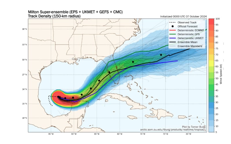
Hurricane Milton is now a Category 5 with maximum sustained winds estimated at 160 mph with higher gusts, and while there remains much uncertainty as to how strong Milton will be at landfall and the exact location of this, BMS Group’s Andrew Siffert has stressed that a landfall around Tampa will be a major event for the insurance industry.

“The rapid intensification is remarkable,” said Siffert, while Milton was still a strong Cat 4. “The formation of a pinhole eye may explain this explosive strengthening, but do not be misled by Milton’s small size. With almost the entire Gulf of Mexico ahead, the storm’s shape and size could still evolve significantly, which will be crucial to the forecast and may have major implications for the insurance industry’s overall losses from Milton.”
This final point is key, as while Milton has become a very powerful storm, its size, shape, and landfall location could change drastically ahead of landfall, which is currently expected early Wednesday evening local time.
After the impacts of hurricane Helene, insurers and reinsurers will be watching Milton closely as this storm is currently forecast to make landfall in a more densely populated part of the Florida coast than Helene did.
“There has been a slight model consensus shift in a landfall location over the last 24 hours to the south of Tampa. Still, this shift is too close for comfort to Tampa, and any landfall location along the central west coast of Florida will be a major event for the insurance industry,” said Siffert.
As Siffert highlights, it’s far too early for industry loss estimates, and how high losses end up will be very sensitive to the actual landfall location and intensity. However, he warns that insured losses could reach into the tens of billions of dollars.
“This is why the catastrophe modeling output to be released will show a broad range of loss estimates. Each one of the tracks will be sensitive to the landfall location and intensity. In fact, in some cases, modeling firms might hold off on issuing early guidance given the forecast uncertainty and the large loss range as right now, an industry loss could be as low as $10B but as high as $100B, so overall guidance is not very useful given the uncertainty,” he explained.
Although now a Cat 5 hurricane, Siffert notes that Milton will encounter a much less favorable environment with strong shear and dry air entrainment after Tuesday night.
“Sea Surface Temperature will be plenty warm, but this season has shown that you need perfect conditions for the intensification of named storms. Therefore, some weakening is anticipated before the hurricane reaches landfall on what looks to be Wednesday early evening. However, just because Milton might be weaker before landfall does not mean it will not be impactful,” said Siffert.
The post Milton landfall along central west coast of Florida will be a major event for re/insurers: BMS appeared first on ReinsuranceNe.ws.